2025-05-06 IDOPRESS

The ‘space brolly’ is nothing to do with geoengineering
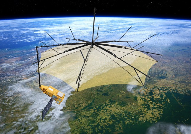
A satellite that looks like a giant parasol was launched into orbit today,and will open itself up automatically in space.
The ‘space brolly’ was made by the European Space Agency,and blasted off this morning from South America.
While geoengineering projects about ‘dimming the sun’ have been in the news lately,this has nothing to do with them.
It’s not going to affect the weather,either by providing us with a cool bit of shade or by keeping the rain off (it’s much too high up for that).
The Biomass satellite is designed to ‘weigh’ forests using radar,to tell us more about the state of the world’s rainforests and jungles.
It will give ‘unprecedented insights’ into their ‘crucial role in Earth’s carbon cycle’,showing us more about how well they are faring.
Its 12-metre-wide mesh reflector (the umbrella bit) is supported by a 7.5-metre boom,and was developed by over 50 companies led by Airbus UK.
We’d better hope that it’s better than our own umbrellas when it comes to getting buffetted by space winds.
Forests absorb and store large amounts of carbon dioxide: around 8 billion tonnes every year.
This makes them important in regulating the planet’s temperature,and they are often called the world’s ‘green lungs’.
When they are cut down or degraded,this carbon is released back into the atmosphere,contributing to global heating.
We know this is a problem,but so far data is scarce on exactly how bad.
It is the first satellite to be equipped with a P-band synthetic aperture radar.
This is a type of radar which is often used to show us more about space,such as the surface of other planets,like Mars.

Are we sure they didn’t just repurpose the 02 Arena (Picture: ESA)
But now it’s being used to create detailed 3D maps of forests and essentially ‘weigh’ them to see how much biomass there is from trees (the total mass of living organisms in an ecosystem at a specific time).
The ESA say this is the first satellite which is ‘capable of penetrating forest canopies to measure woody biomass – trunks,branches,and stems – where most forest carbon is stored.
‘These measurements act as a proxy for carbon storage,the assessment of which is the mission’s primary goal.
‘Data from Biomass will significantly reduce uncertainties in carbon stock and flux estimates,including those related to land-use change,forest loss,and regrowth.’
The agency’s Director of Earth Observation Programmes,Simonetta Cheli,said: ”With Biomass,we are poised to gain vital new data on how much carbon is stored in the world’s forests,helping to fill key gaps in our knowledge of the carbon cycle and,ultimately,Earth’s climate system.’
A Lake Overlooking the Future! “Changsha in One Minute” Takes You into the “Urban Living Room” — Daze Lake
The RA Auto Salon will be held for October 18-20, 2025
Dr. Xuan Xie: Exploring Exclusion to Prosociality in Consumer Contexts
Spain Division: The 9th China (Shenzhen) IEI Competition Now Opens for Registration!
Nanning Rail Transit Investment Group Achieves Remarkable Results at CAEXPO: Empowering ASEAN and BRI Cooperation with Service Capabilities Across the Entire Chain
GEESATCOM Phase I Networking Completed, Achieving Global Real-Time Communication Coverage
©copyright 2009-2020 Singapore Info Map